

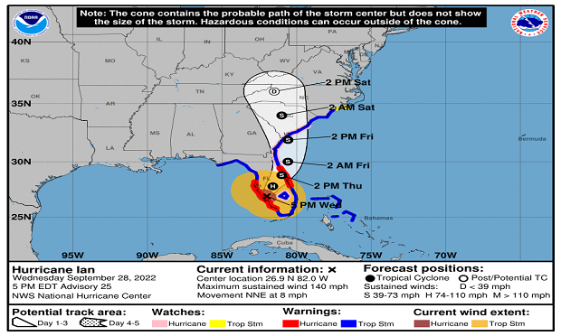
 This image shows the National Hurricane Center's 5-day track and intensity forecast cone of Atlantic AL092022 Hurricane Ian. For more information, visit https://www.nhc.noaa.gov/.
A quiet North Atlantic hurricane season kicked into life Wednesday as Hurricane Ian made landfall in southwest Florida as a high-end Category 4 major weather event. This is the ninth tropical storm of the current season and the fourth hurricane. Early in the day, 18 counties in Florida had issued mandatory or voluntary evacuation orders. National Hurricane Center (NHC) forecasts indicated the eye of Hurricane Ian moved over south-central Florida as it headed north toward the Carolinas.
Want to continue reading?
Become a Free PropertyCasualty360 Digital Reader
Your access to unlimited PropertyCasualty360 content isn’t changing.
Once you are an ALM digital member, you’ll receive:
- All PropertyCasualty360.com news coverage, best practices, and in-depth analysis.
- Educational webcasts, resources from industry leaders, and informative newsletters.
- Other award-winning websites including BenefitsPRO.com and ThinkAdvisor.com.
Already have an account? Sign In
© 2024 ALM Global, LLC, All Rights Reserved. Request academic re-use from www.copyright.com. All other uses, submit a request to [email protected]. For more information visit Asset & Logo Licensing.


