

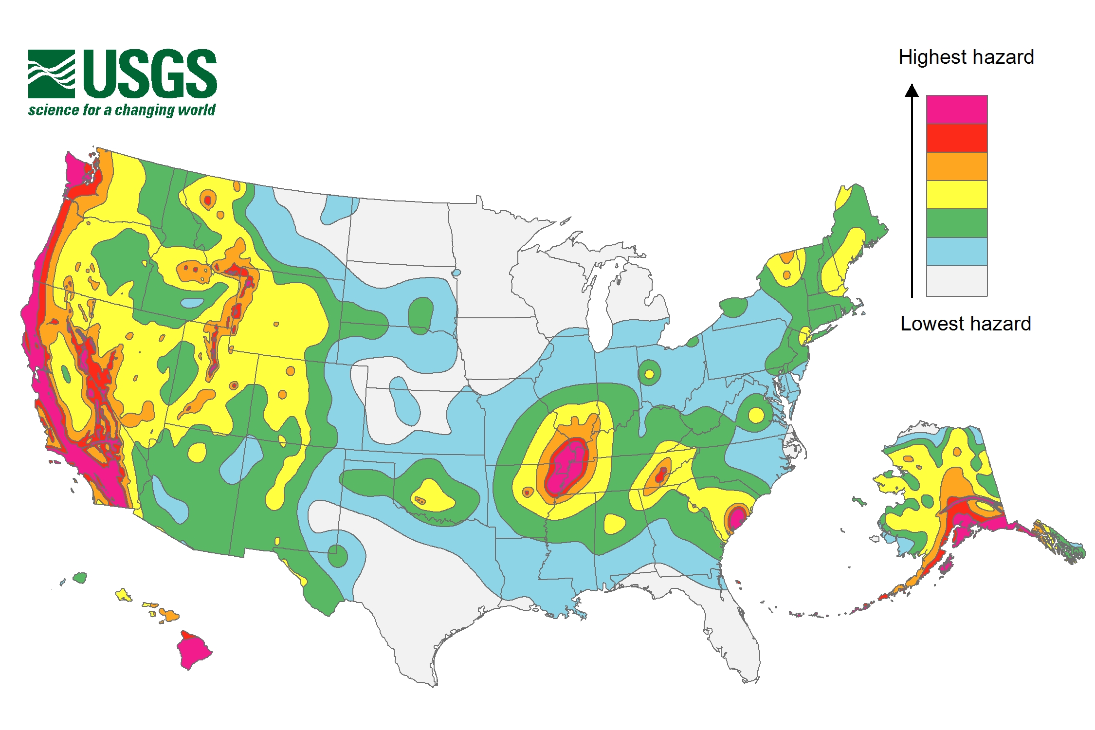
Recently released maps from the U.S. Geological Survey (USGS)identifies 42 states as being at risk for earthquakes, with 16falling into the high risk category and likely to experiencedamaging ground shaking at a magnitude 6 or greater based onprevious quakes.
|The USGS says the hazard is particularly high along the WestCoast, the intermountain west area, and several regions in thecentral and eastern U.S. The states with the highest risk are:Alaska, Arkansas, California, Hawaii, Idaho, Illinois, Kentucky,Missouri, Montana, Nevada, Oregon, South Carolina, Tennessee, Utah,Washington and Wyoming.
|The maps also show that some areas have been identified ashaving potentially stronger quakes than previously thought. Webreak down the possibilities for you by region.
|
East Coast
|After an earthquake hit Virginia in 2011 and was felt inWashington, D.C., Maryland, Delaware, New York and Pennsylvania,throughout New England and as far south as Georgia, the USGS foundthat earthquakes on the East Coast could travel further and causemore damage than originally thought. USGS says earthquake estimatesfor Charleston, S.C., have risen due to an assessment ofearthquakes in the state.
|The maps for New York City indicated that there may be aslightly lower hazard for buildings than previously thought,depending on the type of shaking that occurs. Taller structures aremore likely to be impacted by slower shaking, while shorterbuildings will suffer more damage from fast shaking.
||
Central U.S.
|There is a high risk area that includes portions of Illinois,Missouri, Arkansas, Tennessee and Kentucky. The affected areasexpand to include Indiana, Mississippi, and Alabama with a moremoderate risk hazard. New research from the Nuclear RegulatoryCommission assisted in identifying the risk for the area known asthe New Madrid Seismic Zone. Most of the high risk area is adjacentto the Mississippi River.
|
West Coast
|The high risk area for the West Coast ranges from Washington tothe southernmost tip of California, and includes portions of theeast coast of California and western Nevada. The entire region fromthe west coast of California to portions of Montana, Wyoming,Colorado, New Mexico and Texas, falls into the moderate to highhazard area.
|The new information reduced the earthquake hazard for Irvine,Santa Barbara and Oakland, while increasing it for some parts ofthe San Francisco Bay Area and Los Angeles. Data from recentearthquakes in Mexico, New Zealand and Alaska allowed scientists tosee how fault lines can link together, which expands the number ofareas that can be impacted by a single event.
|This science was applied to California, resulting in themodeling of approximately 250,000 complex ruptures. With newresearch on the CascadiaSubduction Zone, a fault that runs from Northern VancouverIsland to Cape Mendocino, Calif., earthquake magnitude estimateswere increased to 9.3.
||
The value of research
|The maps were the USGS contribution to the National Earthquake HazardsReduction Program, part of a congressionally-establishedpartnership comprising the USGS, Federal Emergency ManagementAgency, the National Institute of Standards and Technology, and theNational Science Foundation. The information compiled from theseagencies will allow states to have more accurate information inorder to plan for worse-case scenarios.
|“USGS earthquake science is vital because you can't plan forearthquakes if you don't know what you are planning for,” said MarkPetersen, Chief of the USGS National Seismic Hazard MappingProject. “Our nation's population and exposure to large earthquakeshas grown tremendously in recent years…It is important tounderstand the threat you face from earthquakes at home and thehazards for the places you might visit. The USGS is dedicated toapplying the best available science in developing reliable productsuseful for reducing the earthquake risk across the U.S.”
Want to continue reading?
Become a Free PropertyCasualty360 Digital Reader
Your access to unlimited PropertyCasualty360 content isn’t changing.
Once you are an ALM digital member, you’ll receive:
- All PropertyCasualty360.com news coverage, best practices, and in-depth analysis.
- Educational webcasts, resources from industry leaders, and informative newsletters.
- Other award-winning websites including BenefitsPRO.com and ThinkAdvisor.com.
Already have an account? Sign In
© 2024 ALM Global, LLC, All Rights Reserved. Request academic re-use from www.copyright.com. All other uses, submit a request to [email protected]. For more information visit Asset & Logo Licensing.


