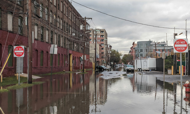
 Pluvial flooding can happen anywhere, even in areas not traditionally considered at risk of flooding. (Credit: Sergey/Adobe Stock)
Increasingly heavy rains are putting pressure on urban infrastructure and flooding unprepared areas, according to a report from Moody’s.
On Monday, intense rainfall caused flash flooding in New York, New Jersey and Connecticut. Roads and highways were closed, and subways flooded. Central Park recorded 2.64 inches of rain, an all-time high for July 14, and LaGuardia saw a record 1.66 inches.
Monday’s floods highlighted the ways aging urban infrastructure is driving pluvial flooding — when intense rainfall overwhelms the ground or drainage systems. Pluvial flooding can happen anywhere, even in areas not traditionally considered at risk of flooding.
“The storm exposed the widespread vulnerability of aging urban infrastructure to short-duration, high-intensity rainfall leading to pluvial flooding, a pattern increasingly common across many U.S. regions,” said Firas Saleh, director of North American Flood Models at Moody’s.
Intense rainfall is escalating in frequency and severity. Daily rainfall records were set 52% more often in 2024 than in 2000 across the globe. As rainfall increases, pluvial flooding is becoming more common, particularly in cities.
Outdated infrastructure is a big contributing factor. In New York, stormwater systems are typically designed to handle a five-year return period storm — or a storm that is statistically expected to happen, on average, about every five years. That translates to about 1.75 inches of rain in an hour. However, that standard was set using data from 1903 to 1951, and it no longer reflects current rainfall trends.
New York’s infrastructure also includes more than 7,400 miles of sewer pipes that carry both sanitary sewage and stormwater. That means about 60% of the system is combined, handling both flows in the same pipes. During heavy rain, combined sewer overflows can occur, releasing untreated sewage and stormwater into local waterways.
More advanced flood maps could help. New York, and many other cities, rely on flood risk maps that use historical data and don't reflect factors like brief intense storms, shifting drainage and sea-level interactions. As pluvial flooding becomes more common, advanced probabilistic models could be used to better assess current and future flood risks.
Even though New York and other cities are increasingly experiencing frequent inland flooding during large storms, flood insurance coverage remains extremely low. That’s leaving many urban residents exposed when flooding occurs outside of traditional floodplains.
© Arc, All Rights Reserved. Request academic re-use from www.copyright.com. All other uses, submit a request to TMSalesOperations@arc-network.com. For more information visit Asset & Logo Licensing.